Tongue River Reflections
Canoeing and Camping Montana's Tongue River
June 1 - 15, 2016
By Thomas J. Elpel
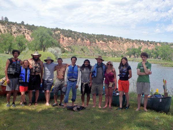
"There is a LOT of private land on the Tongue River," people often say. True. There is a lot of private land on most Montana rivers. Early settlers claimed the rich riparian bottom lands, leaving scattered parcels of rocky hills and cliff faces unclaimed to become today's public lands. No matter, there are usually ample places to camp along Montana rivers, especially in the eastern part of the state where homes and people are scarce. We started below the dam at Tongue River Reservoir State Park and paddled 189 miles over two weeks to Miles City, where the Tongue spills into the Yellowstone River. The Tongue River is scenic and beautiful, arguably one of Montana's finest paddling rivers.
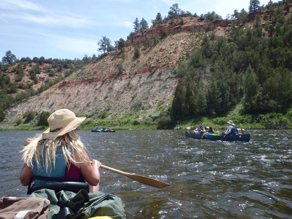 The dream to paddle the Tongue started sixteen years earlier when I brought my family out to camp at Tongue River Reservoir State Park for Easter. Early spring was chilly, yet the hilly red landscape was enchanting. Below the dam we glimpsed the red rock "canyon," a narrow valley rather than a proper canyon, but still stunning. At home, I read about paddling the Tongue in my guidebooks every year, longing to explore this eastern Montana river, yet there was always some reason to hold off, float something else, and save the Tongue for later. Until now.
Our paddling group consisted of eleven paddlers, an eclectic bunch of friends, neighborhood kids, a couple students from our Green University® LLC program, and other individuals who heard about the adventure and asked to join us. We were mostly guys, plus a few gals, coming from states as far away as New York, Texas, and California, plus one man from Australia and my girlfriend Janeth from Sweden. Some of us came with extensive paddling experience, others with little to none.
 It may seem odd to invite or accept complete strangers on a camping trip, but these adventures attract special people, people who know how to have fun without resorting to drugs or alcohol. Arriving and camping by the river below the dam that first night, everyone was immediately out identifying new birds and flowers, and I collected wild clay to make pottery. The guys worked together to start a hand drill fire, and my son Edwin and his friend Jack shot cottontail rabbits with bows and arrows, which we cooked for delicious bunny stew.
My mother and sister also came along, offering to help shuttle vehicles. They would car camp and hike in the area for the first week of the trip, then drive the boys home while the rest of us continued on downriver.
The Tongue River is gentle, perfect for beginning paddlers. Starting below the dam, the river maintains a surprisingly consistent width, depth, and current most of the way to Birney. Coming out of the dam, the water is cool, clear, and rich with nutrients, making a great trout fishery in this upper section. My sister caught a beautiful rainbow trout here. There are few snags or other obstacles in this section of the river, and it is easy to wade into the river or across it almost anywhere. And to my surprise, the river has a wonderful rocky bottom unlike other eastern Montana rivers, which are shin deep in mud. The red sandstone beaches of the Tongue are a joy to explore along the way. The one hazard to watch out for is the intermittent big rocks just below the water, much like the Smith River, which could catch and tip an unwary paddler, or at least gouge the canoe along the angular rock faces.
 The Smith River has the highest user demand in the Montana, and floaters must apply for permits in mid-winter for a chance to float the 59-mile canyon in mid-summer. The Smith also has designated public campsites and pit toilets, which helps accommodate user demand, but arguably also creates user demand. By comparison, the Tongue has only two designated campsites and formal access points along its entire length. There is Tongue River Dam at the beginning, and the Twelve Mile Dam Fishing Access Site near the end. In between there are a few scraps of public land, some of them sizable on the lower Tongue, and a lot of private land. What would happen if there were more public facilities on the Tongue River? Would more floaters travel east and reduce demand on the Smith?
Inquiring locally at the start of our trip, we were told that the first twenty miles of the Tongue River is posted "No Trespassing," and the landowner is militant about enforcing it. Thus I expected to see glaring red signs lining both sides of the river, but fortunately, that was not the case. There were a few red signs at the start of our float, and some small black-and-white signs on fences along the way. Miles of riverbank were not posted at all. Looking into the issue after the trip, I learned that the landowner is Forrest Mars, Jr., a billionaire of Mars, Inc. that makes M&Ms, Mars, Milky Way, and other candies. He bought out local ranches, assembling an 82,000-acre estate that encompasses much of the Tongue River between the dam and Birney. Like a lot of billionaires who come to Montana, Mr. Mars closed the properties to public access.
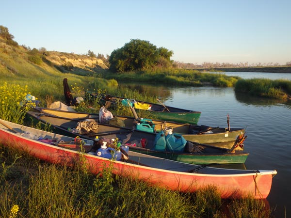 Fortunately, Montana's Stream Access Law allows for camping on private land within the ordinary high water mark. Unfortunately, it is a nebulous definition that arguably doesn't fit the Tongue River, since the high water mark is artificially low due to controlled water releases from the dam. Nevertheless, I identified a wide swath of sedge grass along the bank that would make a legally defensible campsite if the landowner were as confrontational as we'd heard. In addition, we hadn't seen any No Trespassing signs in awhile, and Montana's trespass law allows public use of private property that isn't posted, marked with orange paint, or the landowner hasn't verbally said to leave the premises. Given that the river is paralleled by a dirt road through the canyon, and there are few trees for cover, it seemed like a good idea to set up camp within the legally defensible zone of sedges along the river.
I showed the group the sedge grass patch, and everyone naturally plopped down and made camp immediately above the ordinary high water mark because it is completely instinctual to camp higher than the high water. Common sense is arguably written into our DNA, and it is absurd to have an artificial line dictating that we camp where we instinctively wouldn't. It was a beautiful campsite and we enjoyed our stay. Later, Janeth and I hiked up to the highest point for a breathtaking view south towards the snow-capped Bighorn Mountains in Wyoming, the ultimate source of the Tongue River.
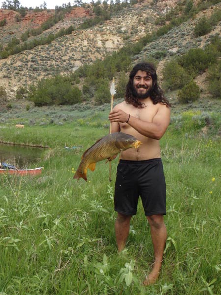 Early June usually finds us on the upper Missouri River near Canyon Ferry Reservoir where we hunt carp with bows and arrows during the spawning run, when water temperatures reach 60ºF. We didn't know what to expect on the Tongue River, but we arrived with a full arsenal of bows and arrows, plus some fishing poles. We apparently hit the end of the spawning season, finding plenty of carp the first half of the trip, gradually becoming scarce as we drifted downstream into warmer waters and theoretically out of the season. However, as carp decreased in number, catfish proved abundant and increasingly large, easily caught using chunks of overripe beef from our cooler for bait. We enjoyed richly seasoned fillets of carp and/or catfish almost nightly. Although we saw people fishing from the riverbank, overall fishing pressure is light, and a catch is virtually guaranteed, even for someone like me, who gets bored after five minutes without any action.
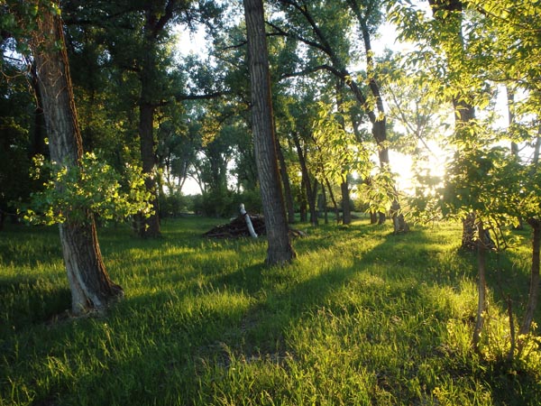 The farther we floated downriver, the less we worried about cantankerous landowners. There are scraps of public land scattered along the river, but they are small, often difficult to identify, and not always suitable for camping. Instead, we camped on private lands in beautiful grassy meadows and shady groves, more or less out-of-sight from roads and houses. We kept a clean camp, leaving no trash behind. We planted a shovel in the middle of camp, so it was easy to grab the tool and take a walk when nature called. We left no messes, and we brought no toilet paper, opting for leaves instead. A fire pan, elevated on rocks, allowed us the full comfort of a campfire, without leaving dead fire pits behind us.
This is Montana as it should be, as it always was, at least until recent times, when people could float and hike and camp anywhere, before out-of-state millionaires and billionaires started buying up Montana ranches and blocking public access with No Trespassing signs. Beyond the reasonable private space around farm homes, all land was effectively public land. Landowners accepted and even appreciated the public, while the public appreciated and respected the landowners. That is the true Montana, the Montana we must reclaim for future generations. And that is the Montana we found as we floated down the Tongue River.
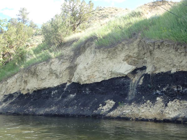
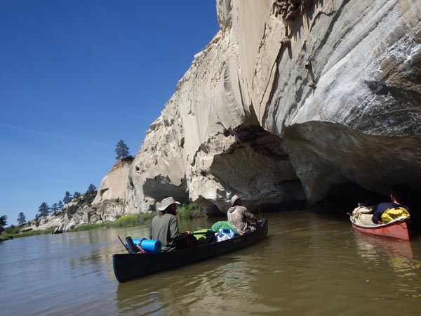
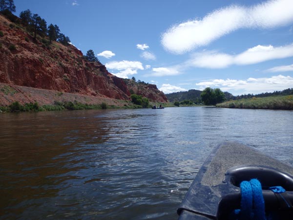 Paddling the Tongue is like taking a gentle journey back through time. Geologically speaking, the landscape is relatively young. From 60 to 35 million years ago the region was a dense, swampy subtropical jungle, soaked by an estimated 120 inches of rainfall per year. Rampant vegetation grew and died, forming peat beds that later formed lignite coal. These organic deposits were intermixed with sandy, silty layers that formed the buff-colored Tongue River sandstone. Additional layers of sediment provided the weight to compress the peat into coal and the sand and silt into sandstone. But those overlying layers later eroded away, bringing the sandstone and coal back to the surface. The river cut through the remaining layers, exposing alternating bands of sandstone, clay, and occasionally coal along the riverbanks. As for the red landscape around Tongue River Reservoir and down the canyon, this was originally buff-colored sandstone, until natural prairie fires ignited coal seams. The coal burned massively hot and deep into the ground, baking the sandstone into hard reddish, brick-like "clinker."
The remaining coal deposits have been the biggest threat to the Tongue River in our time. Arch Coal Inc. bought mining leases from the state of Montana to open the nation's largest coal mine on Otter Creek, a tributary to the Tongue River. The Tongue River Railroad formed as a separate company to construct a railroad up the river to access the coal mine. Local ranchers fought the proposed mine and railroad. Their billionaire neighbor, Forrest Mars, also joined the fray, bringing money and lawyers to fight the railroad that would have crossed his sprawling estate. Ultimately, he solved his problem the way billionaires do: He bought a share of the Tongue River Railroad and redesigned the railroad so it wouldn't cross his land.
 Fortunately, due to concerns over global warming and the falling price of renewable energy sources, coal is becoming uneconomical. Arch Coal, Inc. filed Chapter 11 bankruptcy and abandoned the permitting process for developing the coal deposits. The Tongue River Railroad also put its plans on hold and the permitting process was cancelled. For now at least, the mining proposal and railroad are dead, and the land remains largely untamed.
Moreover, the landscape feels untamed, as if we should float around a curve into a herd of wild bison, complete with wild Indians in pursuit on horseback. Coincidentally, the Tongue River marks the eastern boundary of the Northern Cheyenne Indian Reservation before and after Ashland. We saw no bison, but spooked several small herds of cows and horses across the river ahead of us, clearly unaccustomed to seeing float traffic.
 While launching the Jefferson River Canoe Trail back in 2002, I noted that real estate cost one-tenth as much on the Tongue River compared to the Jefferson. That was just about the time Forrest Mars started buying ranches. I liked to dream big, and I dreamed of buying land along a river like the Tongue, then bringing back the bison. People would be able to float and camp in a remnant piece of the untamed American West as it really was. However, lacking deep pockets to buy big tracts of land, I chose to focus instead on raising funds to secure quality campsites for floaters on the Jefferson River portion of the Lewis and Clark National Historic Trail. I am therefore comforted to know that the American Prairie Foundation is acquiring land in north central Montana for a bison reserve, adjacent to the Charles M. Russell Wildlife Refuge. I hope that someday I will be able to paddle the Missouri River / Fort Peck Reservoir and enjoy a taste of true wildness from the seat of my canoe. Considering the 55,000-acre Fort Keogh Livestock and Range Research Laboratory on the west bank of the lower Tongue, I couldn't help but dream that this federal property might be an appropriate site to start a local bison herd, or to utilize as a brucellosis quarantine facility for surplus Yellowstone bison before shipping them out to states or tribes that want to start their own herds.
Aside from the missing bison, the Tongue River watershed is remarkably intact. The clay soils of eastern Montana favor grasses that spread by underground rhizomes, so bare soil is rarely an issue. By comparison, western Montana has mostly sandy soils that favor bunch grasses. Bunch grasses are dependent on concentrated animal numbers, such as migrating bison herds, to trample seeds, organic matter, and manure fertilizer into the ground to facilitate seedling germination. Without significant hoof impact to replant grasslands, western Montana is becoming increasingly desertified with bare ground that invites knapweed, cheat grass, and other invasive species. Eastern Montana may be drier, but it is more resilient against desertification.
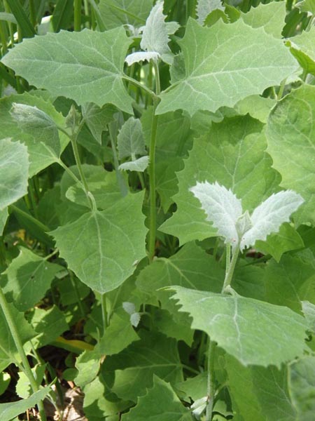 Descending the Tongue brought subtle changes in vegetation. The elevation difference isn't great, approximately 3,300 feet where we started below Tongue River dam, dropping only 1,000 feet over 189 river miles to Miles City, yet the trees respond to the difference. Near the reservoir, plains cottonwoods and box elders line the banks. Farther downstream, ash trees join the riparian forest groves. Invasive Russian olives and tamarisk are established, yet far from dominant. Wild grape vines line the riverbanks below Ashland, but later fade away again. Poison ivy is common below Birney. Wild orache grows along the entire river, providing an abundance of spinach-like greens for our meals. Wild plums were surprisingly scarce. Wild asparagus, however, grew in great profusion along the river, becoming insanely abundant as we moved downstream. Unfortunately, we were too late for that crop, finding only a few asparagus spears that were still good.
Whomever said, "water follows the path of least resistance" never floated the Tongue. It winds back and forth, back and forth, especially from Birney to Ashland, taking the longest possible route between two points. The clear, greenish water near the dam slowly thickens with prairie silt that just gets thicker and thicker all the way downriver. The river is best floated at its own pace, and we largely drifted with the current, paddling around obstacles rather than paddling to get to any destination or push any schedule. Arriving at Ashland at the end of day six, we passed under the first bridge, knowing we could camp at the powwow grounds by the second bridge. By road these bridges are only a mile apart, but by the slow and winding river, the float dragged on for an hour, the longest hour of the journey when we eagerly anticipated camping in town.
 Paddling in a group, night owls often set the schedule, because they like to sleep in until 8 or 9 or 10 a.m. before breaking camp. That worked fine for us. We were an easy-going bunch. Early birds enjoyed morning walks, identifying flowers, journal writing, and cooking breakfast. We were typically packed and on the water by 10 or 11 a.m., just in time for the scorching mid-day heat. Summertime temperatures average 10 to 15 degrees warmer in eastern Montana than at my home in western Montana, with temps ranging between 90 and 100ºF daily on this adventure. We were baked by the sun above, and doubly baked by the sunlight reflecting off the water. Yet, we also applied sunscreen, wore sun hats, swam often along the way, and increasingly covered any bare skin with wet shirts as towels to stay cool and comfortable. Sometimes we ate lunch on the water, grouping the canoes together and passing goodies back and forth. Summer sausage, crackers, and cheese, were regular items on the menu, followed by peanut butter and jelly. We devoured seven big watermelons on the Tongue.
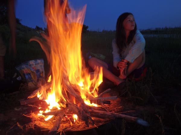
Twice we arose extra early, hitting the water by 6 a.m. one beautiful foggy morning, then beating our time another day when we launched by 5 a.m. These early mornings on the river gave us the leisure of taking long afternoon breaks to rest in the shade or swim and play in the river. In addition to paddling the river and fishing, we practiced primitive skills, making willow baskets, practicing handdrill fire-starting, and I made and fired a clay pot with Tongue River clay. Daylight stretched almost around the clock as we approached the summer solstice, yet even then, each day ended too soon, and we often cooked dinner at dusk and ate by firelight.
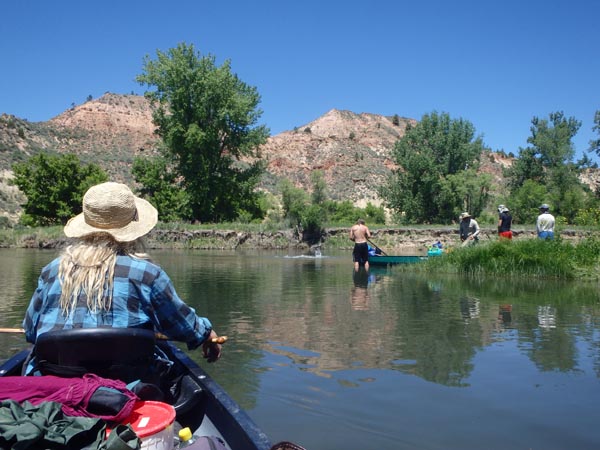
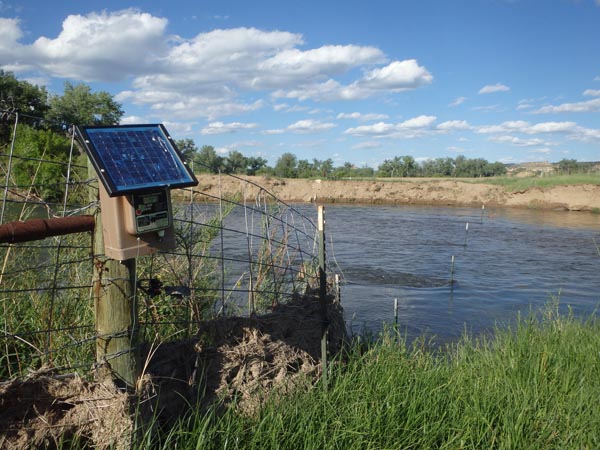 The big wake-up on the river is the fences. Given that the river is shallow enough for livestock to wade across it, ranchers unfortunately strung fences across the river to prevent horses and cows from wandering upstream or downstream to other properties. These fences are the greatest disincentive to float the Tongue River, especially for some distance below Ashland, where the fences became numerous. None are flagged for visibility, and we often didn't seem them until the last minute. Some were electric wires or ribbons, others strands of barbwire. In theory, floaters should have the legal right of way to float through fences with a minimum of difficulty, and at least some fences had a high spot over deep water, allowing boats through while discouraging livestock. We frequently had to duck under barbwire or lift it overhead with a paddle. Some fences we floated under. Others were submerged deep enough that we floated right over them, or pushed the wire down under the boats with a paddle. And then there were the double and triple strand barbwire fences with posts all the way across the river. Fortunately, the water was shallow enough that two guys could stand in the river and spread the wires high and low enough for the rest of the fleet to paddle or push the canoes through the gap.
 If there were more floaters on the Tongue River, then it would be reasonable to expect and demand more floater-friendly fences. Yet, in our two weeks on the river, we never encountered another float party, not even anyone on tubes. It is likely that we are the only party this year to float the whole Tongue River from the reservoir to Miles City!
While fences were a problem on the Tongue, mosquitos were not, and I would gladly accept the lesser of evils. By comparison, the Jefferson River can be intolerable, and mosquitos were bad enough on the Bighorn River, which we floated in 2014, that we had to choose dry, desert-like campsites away from mosquito infested deep grass. We floated the Tongue River earlier, perhaps before the start of mosquito season, but it was certainly warm enough for mosquitos, with temperatures in the 90s almost daily. We only encountered mosquitos during the last couple days of the trip, when we were also hit with passing thundershowers.
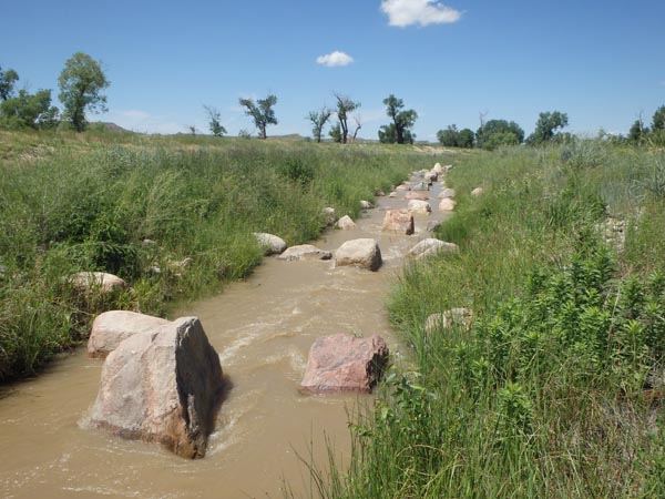 Twelve Mile Dam, a concrete diversion dam upstream from Miles City, was the only truly impassible obstacle on the river. Other rock pile diversion dams on the river have been largely washed away, but we had to portage around this concrete structure. A long sloping fish ladder was constructed around the dam in 2007 to facilitate passage of sauger, catfish, and the endangered pallid sturgeon. We hoped we could walk our canoes through this side stream as well, but it was full of big boulders. Fortunately, we were nearly out of food and water, so the portage wasn't difficult. We unloaded the remaining water and worked as a group to carry each canoe and its contents around the dam.
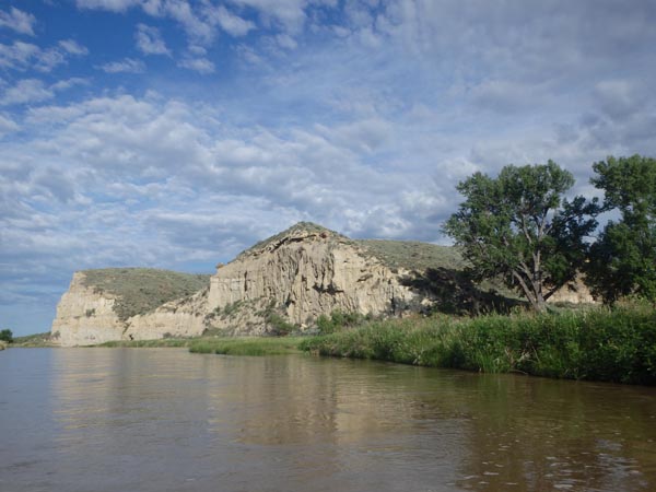 I would love to float the Tongue River again someday, and I would try to start slightly earlier, perhaps May 20th instead of June 1st. That's about the beginning of the irrigation season, when water is released from the reservoir for farms downstream, providing ample water levels for floating. It would also likely be a more optimal window for harvesting wild asparagus and hunting carp during their spawning run.
In the meantime, the state of Montana needs to acquire land for public access sites and campsites along the Tongue River, especially for the red canyon section upstream from Birney, but also at bridges and intermittently along the entire river. The state needs to work with ranchers to install more float-friendly fences. And above all, we need educate out-of-state landowners about Montana's custom and culture of open access for all. Outsiders are welcome in this state, however, they must respect the rights of all people who live here. By buying up land and posting No Trespassing signs, the newcomers make us outsiders in our own homeland. That's not the Montana way.
Read More:
Posted: Please Trespass
Neofeudalism and the Overlords of Montana
Go to Participating in Nature: Wilderness Survival and Primitive Living Skills
Return to the Primitive Living Skills Page


 Primitive Living Skills


 The dream to paddle the Tongue started sixteen years earlier when I brought my family out to camp at Tongue River Reservoir State Park for Easter. Early spring was chilly, yet the hilly red landscape was enchanting. Below the dam we glimpsed the red rock "canyon," a narrow valley rather than a proper canyon, but still stunning. At home, I read about paddling the Tongue in my guidebooks every year, longing to explore this eastern Montana river, yet there was always some reason to hold off, float something else, and save the Tongue for later. Until now.
  It may seem odd to invite or accept complete strangers on a camping trip, but these adventures attract special people, people who know how to have fun without resorting to drugs or alcohol. Arriving and camping by the river below the dam that first night, everyone was immediately out identifying new birds and flowers, and I collected wild clay to make pottery. The guys worked together to start a hand drill fire, and my son Edwin and his friend Jack shot cottontail rabbits with bows and arrows, which we cooked for delicious bunny stew.
  The Smith River has the highest user demand in the Montana, and floaters must apply for permits in mid-winter for a chance to float the 59-mile canyon in mid-summer. The Smith also has designated public campsites and pit toilets, which helps accommodate user demand, but arguably also creates user demand. By comparison, the Tongue has only two designated campsites and formal access points along its entire length. There is Tongue River Dam at the beginning, and the Twelve Mile Dam Fishing Access Site near the end. In between there are a few scraps of public land, some of them sizable on the lower Tongue, and a lot of private land. What would happen if there were more public facilities on the Tongue River? Would more floaters travel east and reduce demand on the Smith?
  Fortunately, Montana's
  Early June usually finds us on the upper Missouri River near Canyon Ferry Reservoir where we
  The farther we floated downriver, the less we worried about cantankerous landowners. There are scraps of public land scattered along the river, but they are small, often difficult to identify, and not always suitable for camping. Instead, we camped on private lands in beautiful grassy meadows and shady groves, more or less out-of-sight from roads and houses. We kept a clean camp, leaving no trash behind. We planted a shovel in the middle of camp, so it was easy to grab the tool and take a walk when nature called. We left no messes, and we brought no toilet paper, opting for leaves instead. A fire pan, elevated on rocks, allowed us the full comfort of a campfire, without leaving dead fire pits behind us.
  Paddling the Tongue is like taking a gentle journey back through time. Geologically speaking, the landscape is relatively young. From 60 to 35 million years ago the region was a dense, swampy subtropical jungle, soaked by an estimated 120 inches of rainfall per year. Rampant vegetation grew and died, forming peat beds that later formed lignite coal. These organic deposits were intermixed with sandy, silty layers that formed the buff-colored Tongue River sandstone. Additional layers of sediment provided the weight to compress the peat into coal and the sand and silt into sandstone. But those overlying layers later eroded away, bringing the sandstone and coal back to the surface. The river cut through the remaining layers, exposing alternating bands of sandstone, clay, and occasionally coal along the riverbanks. As for the red landscape around Tongue River Reservoir and down the canyon, this was originally buff-colored sandstone, until natural prairie fires ignited coal seams. The coal burned massively hot and deep into the ground, baking the sandstone into hard reddish, brick-like "clinker."
  Fortunately, due to concerns over global warming and the falling price of renewable energy sources, coal is becoming uneconomical. Arch Coal, Inc. filed Chapter 11 bankruptcy and abandoned the permitting process for developing the coal deposits. The Tongue River Railroad also put its plans on hold and the permitting process was cancelled. For now at least, the mining proposal and railroad are dead, and the land remains largely untamed.
  While launching the
  Descending the Tongue brought subtle changes in vegetation. The elevation difference isn't great, approximately 3,300 feet where we started below Tongue River dam, dropping only 1,000 feet over 189 river miles to Miles City, yet the trees respond to the difference. Near the reservoir, plains cottonwoods and box elders line the banks. Farther downstream, ash trees join the riparian forest groves. Invasive Russian olives and tamarisk are established, yet far from dominant. Wild grape vines line the riverbanks below Ashland, but later fade away again. Poison ivy is common below Birney. Wild orache grows along the entire river, providing an abundance of spinach-like greens for our meals. Wild plums were surprisingly scarce. Wild asparagus, however, grew in great profusion along the river, becoming insanely abundant as we moved downstream. Unfortunately, we were too late for that crop, finding only a few asparagus spears that were still good.
  Paddling in a group, night owls often set the schedule, because they like to sleep in until 8 or 9 or 10 a.m. before breaking camp. That worked fine for us. We were an easy-going bunch. Early birds enjoyed morning walks, identifying flowers, journal writing, and cooking breakfast. We were typically packed and on the water by 10 or 11 a.m., just in time for the scorching mid-day heat. Summertime temperatures average 10 to 15 degrees warmer in eastern Montana than at my home in western Montana, with temps ranging between 90 and 100ºF daily on this adventure. We were baked by the sun above, and doubly baked by the sunlight reflecting off the water. Yet, we also applied sunscreen, wore sun hats, swam often along the way, and increasingly covered any bare skin with wet shirts as towels to stay cool and comfortable. Sometimes we ate lunch on the water, grouping the canoes together and passing goodies back and forth. Summer sausage, crackers, and cheese, were regular items on the menu, followed by peanut butter and jelly. We devoured seven big watermelons on the Tongue.
  The big wake-up on the river is the fences. Given that the river is shallow enough for livestock to wade across it, ranchers unfortunately strung fences across the river to prevent horses and cows from wandering upstream or downstream to other properties. These fences are the greatest disincentive to float the Tongue River, especially for some distance below Ashland, where the fences became numerous. None are flagged for visibility, and we often didn't seem them until the last minute. Some were electric wires or ribbons, others strands of barbwire. In theory, floaters should have the legal right of way to float through fences with a minimum of difficulty, and at least some fences had a high spot over deep water, allowing boats through while discouraging livestock. We frequently had to duck under barbwire or lift it overhead with a paddle. Some fences we floated under. Others were submerged deep enough that we floated right over them, or pushed the wire down under the boats with a paddle. And then there were the double and triple strand barbwire fences with posts all the way across the river. Fortunately, the water was shallow enough that two guys could stand in the river and spread the wires high and low enough for the rest of the fleet to paddle or push the canoes through the gap.
  If there were more floaters on the Tongue River, then it would be reasonable to expect and demand more floater-friendly fences. Yet, in our two weeks on the river, we never encountered another float party, not even anyone on tubes. It is likely that we are the only party this year to float the whole Tongue River from the reservoir to Miles City!
  Twelve Mile Dam, a concrete diversion dam upstream from Miles City, was the only truly impassible obstacle on the river. Other rock pile diversion dams on the river have been largely washed away, but we had to portage around this concrete structure. A long sloping fish ladder was constructed around the dam in 2007 to facilitate passage of sauger, catfish, and the endangered pallid sturgeon. We hoped we could walk our canoes through this side stream as well, but it was full of big boulders. Fortunately, we were nearly out of food and water, so the portage wasn't difficult. We unloaded the remaining water and worked as a group to carry each canoe and its contents around the dam.
  I would love to float the Tongue River again someday, and I would try to start slightly earlier, perhaps May 20th instead of June 1st. That's about the beginning of the irrigation season, when water is released from the reservoir for farms downstream, providing ample water levels for floating. It would also likely be a more optimal window for harvesting wild asparagus and hunting carp during their spawning run.